Kinn Municipality
Kinn herad | |
|---|---|
 View of the local Kinn Church | |
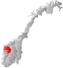
 Sogn og Fjordane within Norway | |
 Kinn within Sogn og Fjordane | |
| Coordinates: 61°33′59″N 04°45′25″E / 61.56639°N 4.75694°E | |
| Country | Norway |
| County | Sogn og Fjordane |
| District | Sunnfjord |
| Established | 1 Jan 1838 |
| • Created as | Formannskapsdistrikt |
| Disestablished | 1 Jan 1964 |
| • Succeeded by | Flora Municipality |
| Administrative centre | Kinn |
| Area (upon dissolution) | |
| • Total | 159 km2 (61 sq mi) |
| Population (1964) | |
| • Total | 3,567 |
| • Density | 22/km2 (58/sq mi) |
| Time zone | UTC+01:00 (CET) |
| • Summer (DST) | UTC+02:00 (CEST) |
| ISO 3166 code | NO-1437[1] |
Kinn is a former municipality in the Sunnfjord district of Sogn og Fjordane county, Norway. The parish of Kinn has existed for centuries and in 1838, the large parish was established as a municipality that existed from then until 1964. The municipality was centered around the island of Kinn where the main Kinn Church is located. The municipality encompassed most of the southern part of the present-day municipality of Kinn (same name, different borders) as well as parts of Askvoll (in the south) and the southwestern part of Bremanger (in the north). Upon its dissolution in 1964, it covered 159 square kilometres (61 sq mi).[2]
On 1 January 2020, the old Kinn name was brought back into use when the municipalities of Flora, Norway and Vågsøy merged, creating a new Kinn Municipality.[2]
- ^ Bolstad, Erik; Thorsnæs, Geir, eds. (26 January 2023). "Kommunenummer". Store norske leksikon (in Norwegian). Kunnskapsforlaget.
- ^ a b Store norske leksikon. "Kinn. – kommune" (in Norwegian). Archived from the original on 29 September 2012. Retrieved 6 November 2013.