 Photograph from the International Space Station | |
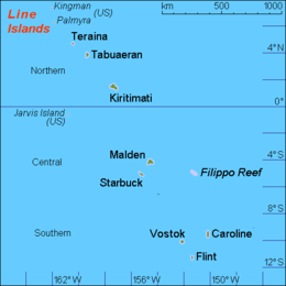
 Map of the Line Islands | |
| Geography | |
|---|---|
| Location | North Pacific Ocean |
| Coordinates | 01°51′00″N 157°24′00″W / 1.85000°N 157.40000°W |
| Archipelago | Line Islands |
| Area | 640.38 km2 (247.25 sq mi) |
| Highest elevation | 13 m (43 ft) |
| Highest point | Joe's Hill |
| Administration | |
| Island council | Kiritimati |
| Largest settlement | Tabwakea (pop. 3,547) |
| Demographics | |
| Population | 7,380 (2020 census) |
| Pop. density | 16.6/km2 (43/sq mi) |
| Languages | Gilbertese |
| Ethnic groups | I-Kiribati |
| Additional information | |
| Time zone | |
Kiritimati (Gilbertese pronunciation: [kiˈrɪsmæs], also known as Christmas Island) is a Pacific Ocean atoll in the northern Line Islands. It is part of the Republic of Kiribati. The name is derived from the English word "Christmas" written in Gilbertese according to its phonology, in which the combination ti is pronounced /s/.
Kiritimati is one of the world's largest atolls in terms of land area, consisting of about 312.38 km2 (120.61 sq mi) land area and a 328 km2 (127 sq mi) network of lagoons;.[1] The atoll is about 150 km (93 mi) in perimeter, while the lagoon shoreline extends for over 48 km (30 mi).[2] Kiritimati comprises over 70% of the total land area of Kiribati, a country encompassing 33 Pacific atolls and islands.[3]
It lies 232 km (144 mi) north of the equator, 2,160 km (1,340 mi) south of Honolulu, and 5,360 km (3,330 mi) from San Francisco. Kiritimati is in the world's furthest forward time zone, UTC+14, and is therefore one of the first inhabited places on Earth to experience New Year's Day (see also Caroline Atoll, Kiribati). Although it lies 2,460 km (1,530 mi) east of the 180th meridian, the Republic of Kiribati realigned the International Date Line in 1995, placing Kiritimati to the west of the dateline.
Nuclear tests were conducted on and around Kiritimati by the United Kingdom in the late 1950s, and by the United States in 1962. During these tests, the island was not evacuated, exposing the i-Kiribati residents and the British, New Zealand, and Fijian servicemen to nuclear radiation.
The entire island is a wildlife sanctuary;[4] access to five particularly sensitive areas is restricted.[1]
- ^ a b Cite error: The named reference
teebaki1993was invoked but never defined (see the help page). - ^ Cite error: The named reference
streets1877was invoked but never defined (see the help page). - ^ "20. Kiritimati" (PDF). Office of Te Beretitenti – Republic of Kiribati Island Report Series. 2012. Archived (PDF) from the original on 14 July 2016. Retrieved 28 April 2015.
- ^ Edward R. Lovell; Taratau Kirata; Tooti Tekinaiti (September 2002). "Status report for Kiribati's coral reefs" (PDF). Centre IRD de Nouméa. Retrieved 29 March 2021.

