This article needs additional citations for verification. (November 2015) |
Kita
北区 | |
|---|---|
Ward of Kyoto | |
 Kinkaku, the Golden Pavilion of Rokuon-ji, is one of the most famous landmarks of Kita-ku. | |
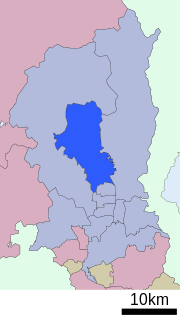
 Location of Kita-ku in Kyoto | |
| Coordinates: 35°2′28″N 135°45′15″E / 35.04111°N 135.75417°E | |
| Country | Japan |
| Prefecture | Kyoto |
| City | Kyoto |
| Founded | 1955 |
| Area | |
| • Total | 94.88 km2 (36.63 sq mi) |
| Highest elevation | 895 m (2,936 ft) |
| Lowest elevation | 60 m (200 ft) |
| Population (October 1, 2020) | |
| • Total | 117,165 |
| • Density | 1,200/km2 (3,200/sq mi) |
| Time zone | UTC+9 (Japan Standard Time) |
| Website | www |
Kita (北区, Kita-ku) is one of the eleven wards in the city of Kyoto, in Kyoto Prefecture, Japan. Its name means "North Ward." As of 2020, the ward has an estimated population of 117,165 people.[1]
Hiragino typeface is named after an area in the ward.
- ^ 京都市統計ポータル/推計人口 (in Japanese). Retrieved April 2, 2022.
