Kitakawabe
北川辺 | |
|---|---|
Former municipality | |
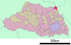
 Location of Kitakawabe in Saitama Prefecture | |
| Coordinates: 36°11′N 139°40′E / 36.183°N 139.667°E | |
| Country | Japan |
| Region | Kantō |
| Prefecture | Saitama Prefecture |
| District | Kitasaitama |
| Merged | March 23, 2010 (now part of Kazo) |
| Area | |
| • Total | 21.00 km2 (8.11 sq mi) |
| Population (June 1, 2009) | |
| • Total | 12,763 |
| • Density | 608/km2 (1,570/sq mi) |
| Time zone | UTC+09:00 (JST) |
| Website | Kitakawabe |
| Symbols | |
| Flower | Iris |
| Tree | Ume |
Kitakawabe (北川辺町, Kitakawabe-machi) was a town located in Kitasaitama District, Saitama Prefecture, Japan.
As of June 1, 2009, the town had an estimated population of 12,763 and a density of 608 persons per km2. The total area was 21.00 km2.
On March 23, 2010, Kitakawabe, along with the towns of Kisai and Ōtone (all from Kitasaitama District), was merged into the expanded city of Kazo.[1] Kitasaitama District was dissolved as a result of this merger.
- ^ "総務省|令和2年版 地方財政白書|資料編 〔附属資料〕 昭和60年度以降の市町村合併の実績" [Record of Municipal Mergers Since Showa 60]. 総務省 (in Japanese). Retrieved 2024-02-28.
