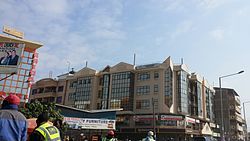
Kitengela | |
|---|---|
 Kitengela | |
| Nickname(s): "Kite," Dusty South, Dustbowl County (DC), Triple K (Kitengela, Kajiado, Kenya) | |
| Coordinates: 1°31′S 36°51′E / 1.517°S 36.850°E | |
| Country | |
| County | Kajiado County |
| Population (2009) | |
| • Total | 154,436[1] |
| Time zone | UTC+3 (EAT) |
Kitengela is a municipality in the Kajiado County of Kenya, located 34 Kilometres south of the capital Nairobi, forming part of the greater Metropolitan Area. Kitengela began as The Kitengela group ranch, made up of 18,292 ha and 214 registered members which was subdivided in 1988 in efforts by the Government to encourage private land ownership in pastoral systems. This had the aim of intensifying and commercializing livestock production. After subdivision of the group ranch, land fragmentation and sales have continued at a steady and escalating pace. The human population within the Kitengela area has more than doubled in the last 10 years, from 6548 in 1989 to 17,347 in 1999 to 58,167 in 2009. There is also a town named Kitengela in the area.
Close to Nairobi National Park is also the Kitengela Game Conservation Area populated with buffalo, Masai giraffe, eastern black rhino, Common eland, impala, Grant's and Thomson's gazelle, common waterbuck and Defassa waterbuck, hippopotamus, common warthog, olive baboon, monkeys and the attendant carnivores – lion, spotted hyena, cheetah, side-striped and black-backed jackals, African golden wolves, bat-eared fox and smaller carnivores.
The diversity of species is decreasing in the Kitengela area adjacent to the Nairobi National Park, where land-uses not compatible with wildlife are increasing.
- ^ "Census 2019 data shows Kenya has a Youthful Rural Population". 2019. Retrieved 16 December 2020.
