Kliptown | |
|---|---|
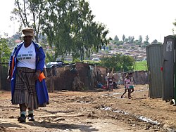
 Kliptown in November 2012 | |
| Coordinates: 26°17′02″S 27°53′13″E / 26.284°S 27.887°E | |
| Country | South Africa |
| Province | Gauteng |
| Municipality | City of Johannesburg |
| Main Place | Soweto |
| Area | |
| • Total | 0.77 km2 (0.30 sq mi) |
| Population (2011)[1] | |
| • Total | 7,548 |
| • Density | 9,800/km2 (25,000/sq mi) |
| Racial makeup (2011) | |
| • Black African | 68.2% |
| • Coloured | 30.6% |
| • Indian/Asian | 0.8% |
| • White | 0.1% |
| • Other | 0.4% |
| First languages (2011) | |
| • Afrikaans | 32.4% |
| • Sotho | 20.5% |
| • Zulu | 14.2% |
| • Tswana | 6.8% |
| • Other | 26.0% |
| Time zone | UTC+2 (SAST) |
| Postal code (street) | 1811 |
| PO box | 1812 |


Kliptown is a suburb of the formerly black township of Soweto in Gauteng, South Africa, located about 17 km south-west of Johannesburg. Kliptown is the oldest residential district of Soweto, and was first laid out in 1891 on land which formed part of Klipspruit farm. The farm was named after the klipspruit (rocky stream) that runs nearby. From 1903 the area was home to informal settlements (squatter camps), and the area now contains a mixture of purpose-built housing and many shacks and other informal homes which form the Chris Hani and Dlamini settlements.
- ^ a b c d "Sub Place Kliptown". Census 2011.

