You can help expand this article with text translated from the corresponding article in German. (April 2018) Click [show] for important translation instructions.
|
| Klostertal | |
|---|---|
| Floor elevation | 1,793 m (5,883 ft)587 |
| Length | 30 KM |
| Geography | |
| Location | Vorarlberg |
| Coordinates | 47°07′23″N 9°59′28″E / 47.123°N 9.991°E |
| Rivers | Alfenz |
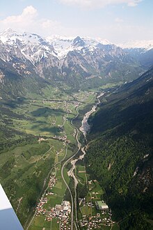
The Klostertal is an alpine valley in Vorarlberg, in Austria. It branches off at Bludenz and extends about 30 kilometers to the east to the Arlberg and the border with Tyrol. It consists of the three communities of Klösterle am Arlberg, Dalaas and Innerbraz and the three Bludenz towns Bings, Radin and Außerbraz with an area of 193.6 km ² and about 4,700 inhabitants (as of 2017).[1]
The valley opens to the east of the district capital Bludenz and is characterized by the south and north steeply towering mountain ranges of the Lechquellen Mountains and the Verwalls mountain range. The Alfenz flows through the Klostertal from Stuben am Arlberg (district of Klösterle/ Arlberg) to the Ill at Bludenz. The bottom of the valley is rising steadily, which is reflected by the fact that the sea level of the settlement areas ranges between 600 m in the west and 1,400 m in the east.

- ^ "Klostertal - Gemeinden - Regio Klostertal". www.klostertal.org. Retrieved 2018-04-04.