This article needs additional citations for verification. (December 2022) |
| Kluane National Park and Reserve | |
|---|---|
| Parc national et réserve de parc national Kluane | |
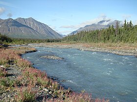
 Quill Creek | |
Location in Canada | |
| Location | Yukon, Canada |
| Nearest city | Haines Junction |
| Coordinates | 60°37′10″N 138°19′52″W / 60.61943°N 138.331°W |
| Area | 5,900 km2 (2,300 sq mi) (park) 22,013 km2 (8,499 sq mi) (total) |
| Established | 1972 as a National Park Reserve. May 29, 1993: an eastern portion of the Reserve became a National Park; the rest continues as a Reserve |
| Visitors | 47,098 (in 2022–23[2]) |
| Governing body | Parks Canada |
| Website | Kluane National Park and Reserve |

| |
| Part of | Kluane / Wrangell-St. Elias / Glacier Bay / Tatshenshini-Alsek |
| Criteria | Natural: (vii), (viii), (ix), (x) |
| Reference | 72 |
| Inscription | 1979 (3rd Session) |
| Extensions | 1992, 1994 |
Kluane National Park and Reserve (/kluːˈɑːniː/; French: Parc national et réserve de parc national de Kluane) are two protected areas in the southwest corner of the territory of Yukon. The National Park Reserve was set aside in 1972 to become a national park, pending settlement of First Nations land claims. It covered an area of 22,013 square kilometres (8,499 square miles). When agreement was reached with the Champagne and Aishihik First Nations over an eastern portion of the Reserve, that part—about 5,900 square kilometres (2,300 square miles)—became a national park in 1993, and is a unit of the national park system administered co-operatively with Parks Canada. The larger western section remains a Reserve, awaiting a final land claim settlement with the Kluane First Nation. The park borders British Columbia to the south, while the Reserve borders both British Columbia to the south, and the United States (Alaska) to the south and west.

The Reserve includes the highest mountain in Canada, Mount Logan (5,959 metres or 19,551 feet) of the Saint Elias Mountains. Mountains and glaciers, including Donjek Glacier, dominate the park's landscape, covering 83% of its area. The rest of the land in the park is forest and tundra—east of the largest mountains and glaciers—where the climate is colder and drier than in the western and southern parts of the park. Trees grow only at the park's lowest elevations. The primary tree species are white spruce, balsam poplar and trembling aspen.[3][4]
- ^ "Protected Planet | Kluane National Park Reserve Of Canada". Protected Planet. Retrieved 2020-10-13.
- ^ Canada, Parks. "Parks Canada attendance 2022_23 - Parks Canada attendance 2022_23 - Open Government Portal". open.canada.ca. Retrieved 2024-05-07.
- ^ "Kluane National Park and Reserve of Canada". Parks Canada. Retrieved 2015-07-30.
- ^ "Kluane National Park and Reserve of Canada: Fact Sheet". Parks Canada. Retrieved 2015-07-30.
