This article needs additional citations for verification. (May 2014) |
Knocklyon
Cnoc Lín | |
|---|---|
Suburb | |
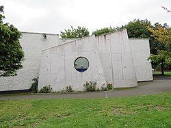
 Knocklyon parish church | |
| Coordinates: 53°17′08″N 6°19′14″W / 53.2856°N 6.3205°W | |
| Country | Ireland |
| Province | Leinster |
| Region | Eastern and Midland Region |
| County | South Dublin |
| Government | |
| • Dáil constituency | Dublin South-West |
| • EU Parliament | Dublin |
| • Local electoral area | Firhouse—Bohernabreena |
| Elevation | 69 m (226 ft) |
| Time zone | UTC+0 (WET) |
| • Summer (DST) | UTC-1 (IST (WEST)) |
Knocklyon (Irish: Cnoc Lín)[2][3] is a suburb of the city of Dublin, located in South Dublin, Ireland. Unlike many Dublin suburbs, Knocklyon was not developed around a village; rather it largely consists of modern housing, with a number of old cottages and farmhouses along Knocklyon Road attesting to the area's rural past.
- ^ "Elevation data from daftlogic.com". Retrieved 30 April 2014.
- ^ "Knocklyon entry at the official Placenames Database of Ireland". Retrieved 17 October 2021.
- ^ "South Dublin Streetnames by Pádraig Ó Cearbhaill at Placenames Database of Ireland" (PDF). p. 2. Archived from the original (PDF) on 14 June 2010. Retrieved 27 January 2010.

