| Kocher | |
|---|---|
 A dam on the Kocher in Oedheim | |
 | |
| Location | |
| Country | Germany |
| Physical characteristics | |
| Source | |
| • location | Swabian Alb |
| • elevation | 510 m (1,670 ft) |
| Mouth | |
• location | Neckar |
• coordinates | 49°13′22″N 9°12′7″E / 49.22278°N 9.20194°E |
| Length | 168.7 km (104.8 mi) [1] |
| Basin size | 1,960 km2 (760 sq mi) [1] |
| Discharge | |
| • average |
|
| Basin features | |
| Progression | Neckar→ Rhine→ North Sea |
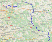
The Kocher (German pronunciation: [ˈkɔxɐ] ) is a 169 km (105 mi)-long[2] right tributary of the Neckar in the north-eastern part of Baden-Württemberg, Germany. The name "Kocher" originates from its Celtic name "cochan" and probably means winding, meandering river. Its total drainage area is 1,960 km2 (760 sq mi).[1] The Kocher rises in the eastern foothills of the Swabian Alb from two karst springs, the Schwarzer (black) Kocher and the Weißer (white) Kocher, that join in Unterkochen near Aalen. The Schwarzer Kocher is approximately 8 km (5.0 mi) long. Its source discharge varies between 50 L/s and 4,000 L/s with an average of 680 L/s. The 3.3 km (2.1 mi) long Weißer Kocher has an average discharge of 400 L/s.
- ^ a b c Map services of the Baden-Württemberg State Office for the Environment, Survey and Conservation (Landesanstalt für Umwelt, Messungen und Naturschutz Baden-Württemberg)
- ^ including its source river Schwarzer Kocher