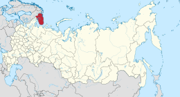
 Kola Peninsula as a part of Murmansk Oblast | |
 Location of Murmansk Oblast within Russia | |
| Geography | |
| Location | Northwest Russia |
| Coordinates | 67°41′18″N 35°56′38″E / 67.68833°N 35.94389°E |
| Adjacent to | |
| Area | 100,000 km2 (39,000 sq mi) |
| Length | 370 km (230 mi) |
| Width | 244 km (151.6 mi) |
| Highest elevation | 1,201 m (3940 ft) |
| Highest point | Yudychvumchorr |
| Administration | |
Russia | |
| oblast | Murmansk Oblast |

The Kola Peninsula (Russian: Ко́льский полуо́стров, romanized: Kólʹskij poluóstrov, Kolsky poluostrov; Kildin Sami: Куэлнэгк нёа̄ррк) is a peninsula located mostly in northwest Russia and partly in Finland and Norway. It is one of the largest peninsulas of Europe. Constituting the bulk of the territory of Murmansk Oblast, it lies almost completely inside the Arctic Circle and is bordered by the Barents Sea to the north and by the White Sea to the east and southeast. The city of Murmansk, the most populous settlement on the peninsula, has a population of roughly 270,000 residents.[1]
While humans had already settled in the north of the peninsula in the 7th–5th millennium BCE, the rest of its territory remained uninhabited until the 3rd millennium BCE, when various peoples started to arrive from the south. By the 1st millennium CE only the Sami people remained. This changed in the 12th century, when Russian Pomors discovered the peninsula's rich resources of game and fish. Soon after, the Pomors were followed by the tribute collectors from the Novgorod Republic, and the peninsula gradually became a part of the Novgorodian lands. The Novgorodians, however, established no permanent settlements until the 15th century.
The Soviet period (1917–1991) saw a rapid population increase, although most of the new arrivals remained confined to urbanized territories along the sea coast and the railroads. The Sami people were subject to forced collectivization, including forced relocation to Lovozero and other centralized settlements, and overall the peninsula became heavily industrialized and militarized, largely due to its strategic position (as the pre-eminent Soviet ice-free Atlantic coast) and to the discovery of the vast apatite deposits in the 1920s. As a result, the peninsula suffered major ecological damage. After the 1991 dissolution of the Soviet Union, the economy went into decline. Its population fell from 1,150,000 in 1989 to 795,000 in 2010. The peninsula recovered somewhat in the early 21st century, and is considered the most industrially developed and urbanized region in northern Russia.
Despite the peninsula's northerly location, its proximity to the North Atlantic Current (an extension of the Gulf Stream) leads to unusually high temperatures in winter, but also results in high winds due to the temperature variations between land and the Barents Sea. Summers are rather chilly, with the average July temperature of only 11 °C (52 °F). The peninsula is covered by taiga in the south and by tundra in the north, where permafrost limits the growth of trees, resulting in landscape dominated by shrubs and grasses. The peninsula supports a small variety of mammals, and its rivers are an important habitat for the Atlantic salmon. The Kandalaksha Nature Reserve, established to protect the population of common eider, is located in the Kandalaksha Gulf. The peninsula is also the site of the Kola Superdeep Borehole, the deepest hole drilled into the Earth.
- ^ 2021 Census of Russian Federation. Kola Peninsula was the site of the detonation of the Tsar Bomba.