| Kon Көң | |
|---|---|
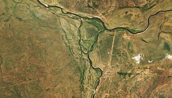
 Mouths of the Kon in the Kulanotpes (top) Sentinel-2 image | |
| Location | |
| Country | Kazakhstan |
| Physical characteristics | |
| Source | Zeldiadyr |
| • coordinates | 49°22′13″N 67°44′06″E / 49.37028°N 67.73500°E (Zhaksykon) |
| • elevation | ca 700 m (2,300 ft) |
| Mouth | Kulanotpes |
• coordinates | 50°11′29″N 69°30′03″E / 50.19139°N 69.50083°E |
• elevation | 320 m (1,050 ft) |
| Length | 160 km (99 mi) |
| Basin size | 4,050 km2 (1,560 sq mi) |
| Discharge | |
| • average | 0.82 m3/s (29 cu ft/s) |
| Basin features | |
| Progression | Kulanotpes→Lake Tengiz |
The Kon (Kazakh: Көң; Russian: Кон) is a river in the Nura District, Karaganda Region, Kazakhstan.[1] It has a length of 160 km (99 mi) and a drainage basin of 4,050 km2 (1,560 sq mi).[2]
The Kon is the most important tributary of the Kulanotpes, followed by the 106 km (66 mi) long Sonaly. 2.5 km (1.6 mi) to the south of its mouth lies Kulanotpes village.[1][2]
- ^ a b "M-42 Topographic Chart (in Russian)". Retrieved 8 May 2024.
- ^ a b Google Earth
