| Kororoit | |
|---|---|
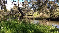
 Kororoit Creek in Albion | |
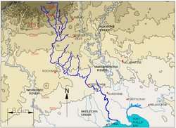
 Contour map of the Kororoit Creek and its tributaries, in Greater Melbourne. | |
| Etymology | Aboriginal (Woiwurrung): creek on western plain[1] |
| Location | |
| Country | Australia |
| State | Victoria |
| Region | Victorian Midlands (IBRA), Greater Melbourne |
| Local government areas | Melton, Brimbank |
| Suburbs | Rockbank, Caroline Springs, Burnside, Kings Park, Albanvale, Deer Park, Cairnlea, West Sunshine, Ardeer, Albion, Brooklyn, Altona North |
| Physical characteristics | |
| Source | Mount Kororoit |
| • location | northeast of Melton |
| • coordinates | 37°38′21″S 144°39′25″E / 37.63917°S 144.65694°E |
| • elevation | 407 m (1,335 ft) |
| Mouth | Altona Bay, Port Phillip |
• location | Altona North |
• coordinates | 37°51′46″S 144°52′12″E / 37.86278°S 144.87000°E |
• elevation | 0 m (0 ft) |
| Length | 52 km (32 mi) |
| Basin features | |
| River system | Port Phillip catchment |
| Tributaries | |
| • left | Jones Creek (Cairnlea, Victoria) |
| National parks | Altona Coastal Park, Jawbone Marine Sanctuary Park |
| [2][3] | |
The Kororoit Creek is a watercourse of the Port Phillip catchment, rising in the outer north western suburbs of Melbourne, in the Australian state of Victoria.
- ^ "Kororoit Creek: 19025: Historical information". VICNAMES. Government of Victoria. 12 August 2012. Archived from the original on 16 April 2014. Retrieved 15 April 2014.
- ^ "Kororoit Creek: 19025". VICNAMES. Government of Victoria. Archived from the original on 16 April 2014. Retrieved 15 April 2014.
- ^ "Map of Kororoit Creek, VIC". Bonzle Digital Atlas of Australia. Retrieved 15 April 2014.