Kozelets
Козелець | |
|---|---|
| Kozelets | |
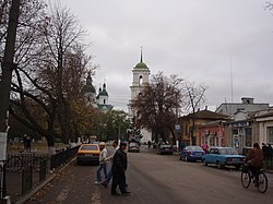
 The town's main street, with the belltower in the background. | |
| Coordinates: 50°54′0″N 31°07′0″E / 50.90000°N 31.11667°E | |
| Country | |
| Oblast | Chernihiv Oblast |
| Raion | Chernihiv Raion |
| Hromada | Kozelets settlement hromada |
| First mentioned | 1098 |
| Magdeburg rights | 1656 |
| Town status | 1924 |
| Government | |
| • Head | Petro Fedchenko |
| Area | |
| • Total | 8.44 km2 (3.26 sq mi) |
| Population (2022) | |
| • Total | 7,496 |
| • Density | 1,037.67/km2 (2,687.6/sq mi) |
| Time zone | UTC+2 (EET) |
| • Summer (DST) | UTC+3 (EEST) |
| Postal code | 17003 |
| Area code | +380 4646 |
| Website | http://rada.gov.ua/ |
Kozelets (Ukrainian: Козелець, IPA: [koˈzelɛtsʲ]) is a rural settlement in Chernihiv Raion, Chernihiv Oblast, northern Ukraine. It hosts the administration of Kozelets settlement hromada, one of the hromadas of Ukraine.[1] Kozelets is located on the Oster River, a tributary of the Dnieper. Population: 7,496 (2022 estimate).[2]
The town was first mentioned in written documents in 1098, but its status as an urban-type settlement (a step below that of a city) was granted in 1924.[3]
Notable attractions in the city includes the Cathedral of the Nativity of the Blessed Virgin designed in the Ukrainian Baroque style by architects Ivan Hryhorovych-Barskyi and Andrei Kvasov. Kozelets also houses several local food industries, and a veterinary technicum.[4]
- ^ "Козелецкая громада" (in Russian). Портал об'єднаних громад України.
- ^ Чисельність наявного населення України на 1 січня 2022 [Number of Present Population of Ukraine, as of January 1, 2022] (PDF) (in Ukrainian and English). Kyiv: State Statistics Service of Ukraine. Archived (PDF) from the original on 4 July 2022.
- ^ "Urban-type settlement Kozelets, Chernihiv Oblast, Kozeletskyi Raion". Verkhovna Rada of Ukraine (in Ukrainian). Archived from the original on 2011-05-21. Retrieved 2008-06-17.
- ^ Cite error: The named reference
eouwas invoked but never defined (see the help page).


