You can help expand this article with text translated from the corresponding article in Ukrainian. (July 2022) Click [show] for important translation instructions.
|
This article needs additional citations for verification. (June 2022) |
Kremenchuk
Кременчук Kremenchug | |
|---|---|
City | |
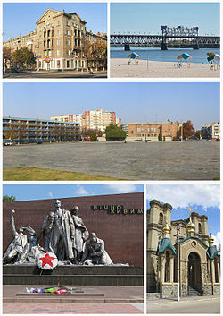
 Top left: Soborna Street, Top right: Dnieper River and Kriukiv Bridge, Center: Victory Square, Bottom left: Memorial to the Forever Alive, Bottom right: Saint Nicolas Church | |
Location in Poltava Oblast | |
| Coordinates: 49°03′47″N 33°24′14″E / 49.06306°N 33.40389°E | |
| Country | |
| Oblast | Poltava Oblast |
| Raion | Kremenchuk Raion |
| Hromada | Krememchuk urban hromada |
| Founded | 1571 |
| Districts | |
| Government | |
| • Mayor | Vitalii Maletskyi |
| Area | |
| • Total | 96 km2 (37 sq mi) |
| Elevation | 80 m (260 ft) |
| Population (2022) | |
| • Total | 215,271 |
| • Density | 2,200/km2 (5,800/sq mi) |
| Time zone | UTC+2 (EET) |
| • Summer (DST) | UTC+3 (EEST) |
| Postcode district(s) | 39600-39689[1] |
| Area code | 5366[2] |
| Vehicle registration | BI[3] |
| Website | www |

Kremenchuk (/ˌkrɛmənˈtʃuːk, ˌkrɪmɪnˈ-/; Ukrainian: Кременчук, IPA: [kremenˈtʃuk] , also spelt Kremenchug) is an industrial city in central Ukraine which stands on the banks of the Dnieper River. The city serves as the administrative center of Kremenchuk Raion and Kremenchuk urban hromada within Poltava Oblast.[4] Its population is approximately 215,271 (2022 estimate),[5] ranking 31st in Ukraine. In 2001, the Ukrainian government included the city in the list of historical settlements.[6]
Although not as large as some oblast centers, Kremenchuk has a large industrial center in Ukraine and Eastern Europe. A KrAZ truck plant, the Kremenchuk Oil Refinery of Ukrtatnafta, the Kriukiv Railway Car Building Works, and Kremenchuk Hydroelectric Power Plant, in nearby Svitlovodsk, are located in or near Kremenchuk. Highway M22 crosses the Dnieper over the dam of the power plant.
Originally established on the left bank, Kremenchuk eventually incorporated the city of Kriukiv on the right bank. The Kriukiv Railway Car Building Works is one of the oldest railway-repair and rail-car-building factories in Eastern Europe, dating from 1869.[7]
- ^ "Ukrainian Zip Codes". Angelfire.
- ^ "Phone Codes for Russia, Ukraine & CIS". russia-ukraine-travel.com. Archived from the original on 2016-11-14. Retrieved 2007-06-21.
- ^ (in Russian) How new plates are decoded www.autoonline.com.ua
- ^ "Кременчугская городская громада" (in Russian). Портал об'єднаних громад України.
- ^ Чисельність наявного населення України на 1 січня 2022 [Number of Present Population of Ukraine, as of January 1, 2022] (PDF) (in Ukrainian and English). Kyiv: State Statistics Service of Ukraine. Archived (PDF) from the original on 4 July 2022.
- ^ "Про затвердження Списку історичних населених місць України". zakon2.rada.gov.ua. 26 July 2021. Archived from the original on 29 December 2012. Retrieved 13 April 2023.
{{cite web}}: CS1 maint: bot: original URL status unknown (link) - ^ "Kryukov Railway Car Building Works". Kryukov Rail Car Building Works Home Page. Archived from the original on 2014-10-06. Retrieved 2014-10-03.


