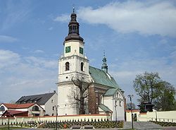
Krzepice | |
|---|---|
 St. Jacob's church | |
| Coordinates: 50°58′2″N 18°43′55″E / 50.96722°N 18.73194°E | |
| Country | |
| Voivodeship | Silesian |
| County | Kłobuck |
| Gmina | Krzepice |
| Established | 12th century |
| City rights | 1357 |
| Government | |
| • Mayor | Krystian Kotynia |
| Area | |
| • Total | 27.71 km2 (10.70 sq mi) |
| Population (2019-06-30[1]) | |
| • Total | 4,456 |
| • Density | 160/km2 (420/sq mi) |
| Time zone | UTC+1 (CET) |
| • Summer (DST) | UTC+2 (CEST) |
| Postal code | 42-160 |
| Area code | +48 34 |
| Vehicle registration | SKL |
| Climate | Cfb |
| Website | http://krzepice.pl/ |
Krzepice pronounced [kʂɛˈpʲit͡sɛ] is a Polish town near Częstochowa, in Kłobuck County, Silesian Voivodeship, in northwestern Lesser Poland. It is near the historic border of Lesser Poland and Silesia, which goes along the Liswarta river. A few kilometers to the northwest, Lesser Poland meets another historic province of the country, Greater Poland.
For centuries, until the Second Partition of Poland in 1793, the town belonged to Lelów County of the Kraków Voivodeship. Annexed by the Kingdom of Prussia as part of New Silesia in 1807, it was passed to the Duchy of Warsaw, and then Congress Poland. In 1918 it returned to Poland, and was part of Kielce Voivodeship. After World War II, Krzepice remained in Kielce Voivodeship until 1950, when it became part of Katowice Voivodeship.
- ^ "Population. Size and structure and vital statistics in Poland by territorial division in 2019. As of 30th June". stat.gov.pl. Statistics Poland. 2019-10-15. Retrieved 2020-03-13.

