Kuala Langat District | |
|---|---|
| Daerah Kuala Langat | |
| Other transcription(s) | |
| • Jawi | كوالا لاڠت |
| • Chinese | 瓜拉冷岳县 |
| • Tamil | கோலா லங்காட் |
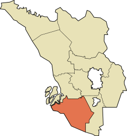
 Location of Kuala Langat District in Selangor | |
 | |
Location of Kuala Langat District in Malaysia | |
| Coordinates: 2°50′N 101°30′E / 2.833°N 101.500°E | |
| Country | |
| State | |
| Seat | Teluk Datok |
| Largest town | Banting |
| Local area government(s) | Kuala Langat Municipal Council |
| Government | |
| • District officer | Rosli Othman[1] |
| • Sultan's Representative | Mohamed Al Haj Harun[2] |
| Area | |
| • Total | 858 km2 (331 sq mi) |
| Population (2020)[4] | |
| • Total | 307,787 |
| • Density | 360/km2 (930/sq mi) |
| Time zone | UTC+8 (MST) |
| • Summer (DST) | UTC+8 (Not observed) |
| Postcode | 425xx-428xx, 471xx |
| Calling code | +6-03-31, +6-03-51, +6-03-5614, +6-03-80 |
| Vehicle registration plates | B |

The Kuala Langat District is a district of Selangor, Malaysia. It is situated in the southwestern part of Selangor. It covers an area of 858 square kilometres, and had a population of 307,787 at the 2020 Census (exclude foreign).[4] It is bordered by the districts of Klang and Petaling to the north and Sepang to the east. The Strait of Malacca forms its western border.
Among the major towns in Kuala Langat are Banting, Jugra, Teluk Datok, Morib and an island Carey Island.
- ^ "Portal Rasmi PDT Kuala Langat Perutusan Pegawai Daerah Kuala Langat". www2.selangor.gov.my. 2016-06-06. Archived from the original on 2016-09-23.
- ^ "Portal Rasmi PDT Kuala Langat Orang Besar Daerah". www2.selangor.gov.my. 2017-01-23. Archived from the original on 2017-02-04.
- ^ "Portal Rasmi PDT Kuala Langat Profil Kuala Langat". www2.selangor.gov.my. 2016-08-30. Archived from the original on 2020-10-25.
- ^ a b "Population Distribution and Basic Demographic Characteristics, 2010" (PDF). Department of Statistics, Malaysia. Archived from the original (PDF) on 22 May 2014. Retrieved 19 April 2012.

