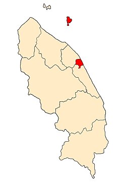
Kuala Terengganu District | |
|---|---|
| Daerah Kuala Terengganu | |
| Other transcription(s) | |
| • Jawi | كوالا ترڠڬانو |
| • Chinese | 瓜拉登嘉楼县 |
 Location of Kuala Terengganu District in Terengganu | |
 | |
Location of Kuala Terengganu District in Malaysia | |
| Coordinates: 5°20′N 103°10′E / 5.333°N 103.167°E | |
| Country | |
| State | |
| Seat | Kuala Terengganu |
| Local area government(s) | Kuala Terengganu City Council |
| Government | |
| • District officer | Azmi Razik |
| Area | |
| • Total | 210.21 km2 (81.16 sq mi) |
| Population | |
| • Total | 343,284 |
| • Estimate (2014)[3] | 184,600 |
| • Density | 1,600/km2 (4,200/sq mi) |
| Time zone | UTC+8 (MST) |
| • Summer (DST) | UTC+8 (Not observed) |
| Postcode | 21xxx |
| Calling code | +6-09-6 |
| Vehicle registration plates | T |
The Kuala Terengganu District is a district in the state of Terengganu, Malaysia. It covers an area of 210.21 square kilometres, and had a population of 343,284 at the 2010 Census .[2] The district is bordered by Terengganu River which separates Kuala Nerus District in the north and west, Marang District in the south and South China Sea in the east. The capital of this district is Kuala Terengganu.
- ^ Administrator. "Laman Web Rasmi Pejabat Daerah Dan Tanah Kuala Nerus". pdtknerus.terengganu.gov.my. Archived from the original on 2021-01-20. Retrieved 2017-12-25.
- ^ a b "Population Distribution and Basic Demographic Characteristics, 2010" (PDF). Department of Statistics, Malaysia. Archived from the original (PDF) on 22 May 2014. Retrieved 19 April 2012.
- ^ Administrator. "Pengenalan Daerah Dungun". pdtdungun.terengganu.gov.my.

