Native name: Japanese: 口永良部島 | |
|---|---|
 Kuchinoerabu-jima from Nagatadake on Yakushima | |
 | |
| Geography | |
| Location | East China Sea |
| Coordinates | 30°28′N 130°11′E / 30.467°N 130.183°E |
| Archipelago | Ōsumi Islands |
| Area | 38.04 km2 (14.69 sq mi) |
| Length | 12 km (7.5 mi) |
| Width | 5 km (3.1 mi) |
| Coastline | 49.67 km (30.864 mi) |
| Highest elevation | 657 m (2156 ft) |
| Highest point | Furudake |
| Administration | |
| Kagoshima Prefecture | |
| Demographics | |
| Population | 147 (2010) |
| Pop. density | 3.86/km2 (10/sq mi) |
| Ethnic groups | Japanese |
| Additional information | |
| Last eruption date 2020 | |
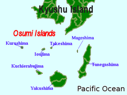
Kuchinoerabu-jima (口永良部島), is one of the Satsunan Islands, usually classed with the Ōsumi Islands belonging to Kagoshima Prefecture, Japan. The island, 38.04 km2 (14.69 sq mi) in area, has a population of 147. The island can only be reached by boat as it has no airport. There is regular ferry service with Yakushima, which is about 15 km to the east. Travel time is approximately 1 hour. The islanders are dependent mainly on fishing, agriculture and seasonal tourism. The entire island is within the borders of the Kirishima-Yaku National Park.