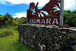
Kumara | |
|---|---|
 Sign beside SH 73 on the outskirts of Kumara | |
 | |
| Coordinates: 42°37′52″S 171°11′13″E / 42.63111°S 171.18694°E | |
| Country | New Zealand |
| Region | West Coast |
| District | Westland District |
| Ward | Northern |
| Electorates | |
| Government | |
| • Territorial authority | Westland District Council |
| • Regional council | West Coast Regional Council |
| • Mayor of Westland | Helen Lash |
| • West Coast-Tasman MP | Maureen Pugh |
| • Te Tai Tonga MP | Tākuta Ferris |
| Area | |
| • Total | 2.69 km2 (1.04 sq mi) |
| Population (June 2024)[2] | |
| • Total | 310 |
| • Density | 120/km2 (300/sq mi) |
| Time zone | UTC+12 (NZST) |
| • Summer (DST) | UTC+13 (NZDT) |
| Postcode | 7832 |
| Area code | 03 |
| Local iwi | Ngāi Tahu |
Kumara is a town on the West Coast of the South Island of New Zealand. It is located 30 kilometres (19 mi) south of Greymouth, close to the western end of State Highway 73, which leads across Arthur's Pass to Christchurch. The Taramakau River flows past to the north.[3][4]
The population was 285 in the 2018 census, a decrease of 24 (7.76%) from 2013.
The name may come from the Māori language Kohe mara, which is the blossom of the tātarāmoa, or bush lawyer.[5]
The Coast to Coast annual multisport race starts at Kumara Beach.[6]
- ^ Cite error: The named reference
Areawas invoked but never defined (see the help page). - ^ "Aotearoa Data Explorer". Statistics New Zealand. Retrieved 26 October 2024.
- ^ Peter Dowling, ed. (2004). Reed New Zealand Atlas. Reed Books. map 69. ISBN 0-7900-0952-8.
- ^ Roger Smith, GeographX (2005). The Geographic Atlas of New Zealand. Robbie Burton. map 156. ISBN 1-877333-20-4.
- ^ Cite error: The named reference
ENZ1966was invoked but never defined (see the help page). - ^ "Race profile: Speight's Coast to Coast". Coast to Coast. 2014. Archived from the original on 13 January 2015. Retrieved 13 January 2015.