Kumluca | |
|---|---|
District and municipality | |
 Aerial view | |
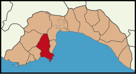
 Map showing Kumluca District in Antalya Province | |
| Coordinates: 36°22′N 30°17′E / 36.367°N 30.283°E | |
| Country | Turkey |
| Province | Antalya |
| Government | |
| • Mayor | Mesut Avcıoğlu (DP) |
| Area | 1,225 km2 (473 sq mi) |
| Elevation | 15 m (49 ft) |
| Population (2022)[1] | 73,496 |
| • Density | 60/km2 (160/sq mi) |
| Time zone | UTC+3 (TRT) |
| Postal code | 07350 |
| Area code | 0242 |
| Website | www |
Kumluca is a municipality and district of Antalya Province, Turkey.[2] Its area is 1,225 km2,[3] and its population is 73,496 (2022).[1] It lies on the Mediterranean coast, and is part of the Turkish Riviera. Kumluca is located 90 km (56 mi) west of the city of Antalya, on the Teke Peninsula, (between the bays of Antalya and Fethiye). Its neighbour towns are Korkuteli, Elmalı, Finike, Kemer and Antalya
The town of Kumluca, formerly the village of Sarıkavak, is named for its sandy soil (kum meaning sand in Turkish), good for growing watermelons.
- ^ a b "Address-based population registration system (ADNKS) results dated 31 December 2022, Favorite Reports" (XLS). TÜİK. Retrieved 22 May 2023.
- ^ Büyükşehir İlçe Belediyesi, Turkey Civil Administration Departments Inventory. Retrieved 8 June 2023.
- ^ "İl ve İlçe Yüz ölçümleri". General Directorate of Mapping. Retrieved 22 May 2023.
