| Kurnell Sydney, New South Wales | |||||||||||||||
|---|---|---|---|---|---|---|---|---|---|---|---|---|---|---|---|
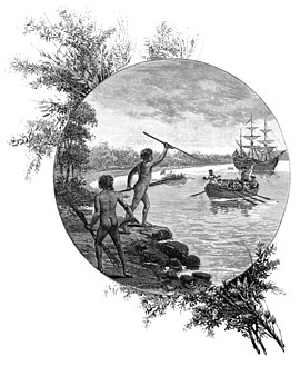
 Artwork depicting two Gweagal opposing the landing of James Cook and crew | |||||||||||||||
 | |||||||||||||||
| Population | 2,528 (2021 census)[1] | ||||||||||||||
| Postcode(s) | 2231 | ||||||||||||||
| Elevation | 19 m (62 ft) | ||||||||||||||
| Location | 22 km (14 mi) S of Sydney CBD | ||||||||||||||
| LGA(s) | Sutherland Shire | ||||||||||||||
| State electorate(s) | Cronulla | ||||||||||||||
| Federal division(s) | Cook | ||||||||||||||
| |||||||||||||||
Kurnell is a suburb in Sydney, in the state of New South Wales, Australia. It is 21.4 kilometres (13.3 mi) south of the Sydney central business district, in the local government area of the Sutherland Shire along the east coast. Cronulla and Woolooware are the only adjacent suburbs. La Perouse is located opposite, on the northern headland of Botany Bay. The Cronulla sand dunes are on the south eastern headland of Botany Bay. The eastern side of the peninsula is part of Botany Bay National Park, and Towra Point Nature Reserve is located on the western side of the suburb.
- ^ Australian Bureau of Statistics (28 June 2022). "Kurnell (State Suburb)". 2021 Census QuickStats. Retrieved 14 September 2024.