| Kushmurun | |
|---|---|
| Құсмұрын / Кушмурун | |
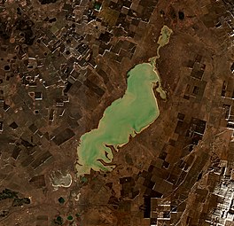
 Sentinel-2 image of the lake in 2020. | |
| Location | Turgay Basin |
| Coordinates | 52°41′N 64°48′E / 52.683°N 64.800°E |
| Type | fluvial lake |
| Primary inflows | Ubagan, Aschiba, Terekty and Shiyly |
| Primary outflows | Ubagan |
| Catchment area | 10,500 square kilometers (4,100 sq mi) |
| Basin countries | Kazakhstan |
| Max. length | 60 kilometers (37 mi) |
| Max. width | 15 kilometers (9.3 mi) |
| Surface area | 415 square kilometers (160 sq mi) |
| Max. depth | 3.5 meters (11 ft) |
| Surface elevation | 103 meters (338 ft) |
Kushmurun (Kazakh: Құсмұрын; Russian: Кушмурун) is a brackish lake in the Kostanay Region, Kazakhstan.[1]
Kushmurun is one of largest natural waterbodies of Kazakhstan. It lies in the northern sector of the Turgay Basin, at the border between Auliekol and Karasu districts, 9 kilometers (5.6 mi) north of the village of Kushmurun. The western side of the catchment area of the lake has been converted to agricultural land, affecting biodiversity.[2][3]
- ^ "N-41 Topographic Chart (in Russian)". Retrieved 24 July 2022.
- ^ Cite error: The named reference
GЕwas invoked but never defined (see the help page). - ^ Kushmurun Lake, Kazakhstan - KeyBiodiversityAreas.org
