Kutaisi uezd
Кутаисскій уѣздъ | |
|---|---|
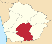
 Location in the Kutaisi Governorate | |
| Country | Russian Empire |
| Viceroyalty | Caucasus |
| Governorate | Kutaisi |
| Established | 1846 |
| Abolished | 1928 |
| Capital | Kutais (present-day Kutaisi) |
| Area | |
| • Total | 2,324.65 km2 (897.55 sq mi) |
| Population (1916) | |
| • Total | 291,969 |
| • Density | 130/km2 (330/sq mi) |
| • Urban | 19.92% |
| • Rural | 80.08% |
The Kutaisi uezd[a] was a county (uezd) of the Kutaisi Governorate of the Caucasus Viceroyalty of the Russian Empire. It bordered the Akhaltsikhe uezd of the Tiflis Governorate to the south, the Ozurgeti and Senaki uezds to the west, the Lechkhumi and Racha uezds to the north, and the Shorapani uezd to the east. The area of the uezd corresponded to most of the contemporary Imereti region of Georgia. The Kutaisi uezd was eponymously named for its administrative center, Kutais (present-day Kutaisi).[1]
Cite error: There are <ref group=lower-alpha> tags or {{efn}} templates on this page, but the references will not show without a {{reflist|group=lower-alpha}} template or {{notelist}} template (see the help page).
