Kuujjuaq
ᑰᑦᔪᐊᖅ | |
|---|---|
 Kuujjuaq | |
| Coordinates (Hôtel de ville Katittavik, 400, chemin de l'Aéroport[2]): 58°06′N 68°24′W / 58.100°N 68.400°W[1][3] | |
| Country | Canada |
| Province | Quebec |
| Region | Nord-du-Québec Nunavik |
| TE | Kativik |
| Constituted | December 29, 1979 |
| Government | |
| • Mayor | Mary Johannes |
| • Federal riding | Abitibi—Baie-James—Nunavik—Eeyou |
| • Prov. riding | Ungava |
| Area | |
| • Total | 385.70 km2 (148.92 sq mi) |
| • Land | 289.97 km2 (111.96 sq mi) |
| Population (2021)[4] | |
| • Total | 2,668 |
| • Density | 9.2/km2 (24/sq mi) |
| • Change (2016–21) | |
| • Dwellings | 1,253 |
| Time zone | UTC−05:00 (EST) |
| • Summer (DST) | UTC−04:00 (EDT) |
| Postal code(s) | |
| Area code | 819 |
| Website | www |
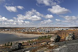
Kuujjuaq ([kuːtjuɑq]; Inuktitut: ᑰᑦᔪᐊᖅ or ᑰᔾᔪᐊᖅ, "Great River"),[5] formerly known as Suoivauqaj (ᓲᐃᕙᐅᖃᔾ) and by other names, is a former Hudson's Bay Company outpost at the mouth of the Koksoak River on Ungava Bay that has become the largest northern village (Inuit community) in the Nunavik region of Quebec, Canada. It is the administrative capital of the Kativik Regional Government. Its population was 2,668 as of the 2021 census.
- ^ "Kuujjuaqa". Geographical Names Data Base. Natural Resources Canada.
- ^ a b c Cite error: The named reference
mamrotwas invoked but never defined (see the help page). - ^ Cite error: The named reference
toponymiewas invoked but never defined (see the help page). - ^ a b Cite error: The named reference
cp2021was invoked but never defined (see the help page). - ^ Taamusi Qumaq (1992). "ᑰᑦᔪᐊᖅ". Avataq. Retrieved August 26, 2020.

