 LAGEOS-1 (diameter=60 cm [23.6 inches]) | |
| Mission type | Geodesy |
|---|---|
| COSPAR ID | 1976-039A |
| SATCAT no. | 8820 |
| Website | ilrs.cddis.eosdis.nasa.gov |
| Mission duration | 48 years, 6 months and 14 days (in progress) |
| Spacecraft properties | |
| Spacecraft type | GEOS |
| Manufacturer | NASA |
| Launch mass | 406.965 kilograms (897.20 lb) |
| Dimensions | 0.60 metres (2 ft 0 in) diameter sphere |
| Start of mission | |
| Launch date | 4 May 1976, 08:00 UTC[1] |
| Rocket | Delta 2913 / Star-24 |
| Launch site | Vandenberg SLC-2W |
| Contractor | NASA |
| End of mission | |
| Disposal | Re-Entry |
| Decay date | in 8 Million Years |
| Orbital parameters | |
| Reference system | Geocentric |
| Regime | Medium Earth |
| Semi-major axis | 12,271.15 kilometers (7,624.94 mi) |
| Eccentricity | 0.0044560 |
| Perigee altitude | 5,838.33 kilometers (3,627.77 mi) |
| Apogee altitude | 5,947.69 kilometers (3,695.72 mi) |
| Inclination | 109.83 degrees |
| Period | 225.70 minutes |
| Epoch | 5 May 2017, 07:05:23 UTC[2] |
| Instruments | |
| |
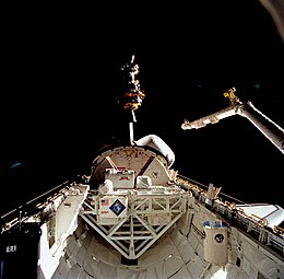
 Deployment of LAGEOS 2 during STS-52 | |
| Mission type | Geodesy |
|---|---|
| Operator | NASA |
| COSPAR ID | 1992-070B |
| SATCAT no. | 22195 |
| Website | ilrs.cddis.eosdis.nasa.gov |
| Mission duration | 32 years and 27 days (in progress) |
| Spacecraft properties | |
| Spacecraft type | LAGEOS |
| Manufacturer | Aeritalia for the Italian Space Agency (ASI) |
| Launch mass | 405.38 kilograms (893.7 lb) |
| Dimensions | 0.60 metres (2 ft 0 in) diameter sphere |
| Start of mission | |
| Launch date | 22 October 1992, 17:09 UTC[1] |
| Rocket | Space Shuttle STS-52 / Italian Research Interim Stage (IRIS) |
| Launch site | Kennedy LC-39B |
| End of mission | |
| Disposal | Re-Entry |
| Decay date | in 8 Million years |
| Orbital parameters | |
| Reference system | Geocentric |
| Regime | Medium Earth |
| Semi-major axis | 12,161.84 kilometers (7,557.02 mi) |
| Eccentricity | 0.0137298 |
| Perigee altitude | 5,616.73 kilometers (3,490.07 mi) |
| Apogee altitude | 5,950.68 kilometers (3,697.58 mi) |
| Inclination | 52.65 degrees |
| Period | 222.46 minutess |
| Epoch | 5 May 2017, 07:48:20 UTC[2] |
| Instruments | |
| |

LAGEOS (/leɪʒiːoʊs/), Laser Geodynamics Satellite or Laser Geometric Environmental Observation Survey, are a series of two scientific research satellites designed to provide an orbiting laser ranging benchmark for geodynamical studies of the Earth. Each satellite is a high-density passive laser reflector in a very stable medium Earth orbit (MEO).
- ^ a b McDowells, Jonathan. "Launch Log". Jonathan's Space Page. Retrieved 6 May 2017.
- ^ a b "Celestrak NORAD Two-Line Element Sets". 5 May 2017. Retrieved 6 May 2017.