| La Chute River | |
|---|---|
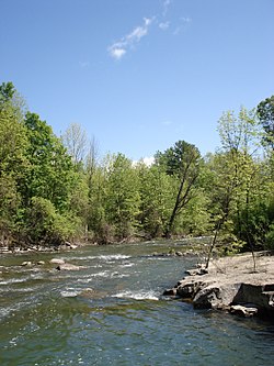
 The river near Ticonderoga, New York | |
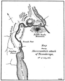
 Fall River Route
between Lakes George and Champlain. (1758) | |
| Location | |
| Country | United States |
| State | New York |
| Region | Adirondacks |
| County | Essex |
| City | Ticonderoga |
| Physical characteristics | |
| Source | Lake George |
| • coordinates | 43°50′13″N 73°25′52″W / 43.8369444°N 73.4311111°W[1] |
| • elevation | 318 feet (97 m)[2] |
| Mouth | Lake Champlain |
• coordinates | 43°50′10″N 73°23′38″W / 43.8361712°N 73.3940076°W[1] |
• elevation | 92 feet (28 m)[1] |
| Length | 3.7 mi (6 km) |
The La Chute River, also known as Ticonderoga Creek, is a short, fast-moving river, near the Vermont–New York border. It is now almost wholly contained within the municipality of Ticonderoga, New York, connecting the northern end and outlet of the 32-mile (51 km) long Lake George and the southern end of the 107-mile (172 km) long Lake Champlain[3] through many falls and rapids. The river drops about 230 feet (70 m) in its three and a half-mile (6 km) course, which is a larger drop than Niagara Falls (167 ft (52 m)).
Part of the Lake Champlain Valley and the St. Lawrence River drainage basin, ultimately its waters flow out of Lake Champlain through the 106 miles (171 km) length of the Richelieu River into the St. Lawrence River and then into the North Atlantic Ocean north of Nova Scotia.
- ^ a b c "La Chute". Geographic Names Information System. United States Geological Survey, United States Department of the Interior. Retrieved August 21, 2021.
- ^ "Lake George". Geographic Names Information System. United States Geological Survey, United States Department of the Interior. Retrieved August 21, 2021.
- ^ "Lake Champlain | lake, Canada-United States | Britannica".

