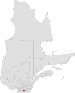
La Haute-Yamaska | |
|---|---|
 | |
| Coordinates: 45°24′N 72°44′W / 45.400°N 72.733°W[1] | |
| Country | |
| Province | |
| Region | Estrie |
| Effective | March 3, 1982 |
| County seat | Granby |
| Government | |
| • Type | Prefecture |
| • Prefect | Pascal Russell |
| Area | |
| • Total | 650.40 km2 (251.12 sq mi) |
| • Land | 636.00 km2 (245.56 sq mi) |
| Population (2021)[3] | |
| • Total | 92,796 |
| • Density | 145.9/km2 (378/sq mi) |
| • Change 2016-2021 | |
| • Dwellings | 41,563 |
| Time zone | UTC−5 (EST) |
| • Summer (DST) | UTC−4 (EDT) |
| Area code(s) | 450 and 579 |
| Website | www |
| [4] | |
La Haute-Yamaska (meaning The Upper Yamaska) is a regional county municipality in the Estrie region of Quebec, Canada. Its seat is Granby.
It is named for its position at the height of the Yamaska River, which cuts through its southern part. It rises at Brome Lake located in neighbouring Brome-Missisquoi Regional County Municipality.
On January 1, 2010, the city of Bromont left La Haute-Yamaska; it was reclassified to the Brome-Missisquoi RCM.[5]
In 2021, it was transferred to the Estrie region from Montérégie.[6]
- ^ Cite error: The named reference
toponymiewas invoked but never defined (see the help page). - ^ Cite error: The named reference
mamrotwas invoked but never defined (see the help page). - ^ a b "Census Profile, 2021 Census: La Haute-Yamaska, Municipalité régionale de comté [Census division], Quebec". Statistics Canada. Retrieved September 8, 2021.
- ^ "Census Profile, 2021 Census, Statistics Canada - Validation Error".
- ^ "Modifications aux municipalités du Québec" (PDF) (in French). Institut de la statistique du Québec. p. 4. Retrieved November 25, 2019.
- ^ "La Haute-Yamaska et Brome-Missisquoi entrent dans le giron de l'Estrie". La Tribune. 8 July 2021. Retrieved October 15, 2021.