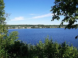
Lac-Bouchette | |
|---|---|
 | |
 | |
| Coordinates: 48°15′N 72°11′W / 48.25°N 72.18°W[1] | |
| Country | |
| Province | |
| Region | Saguenay–Lac-Saint-Jean |
| RCM | Le Domaine-du-Roy |
| Settled | 1882 |
| Constituted | September 25, 1971 |
| Government | |
| • Mayor | Benoît Gélinas |
| • Federal riding | Roberval—Lac-Saint-Jean |
| • Prov. riding | Roberval |
| Area | |
| • Total | 972.20 km2 (375.37 sq mi) |
| • Land | 908.63 km2 (350.82 sq mi) |
| Population (2011)[3] | |
| • Total | 1,174 |
| • Density | 1.3/km2 (3/sq mi) |
| • Pop (2006–11) | |
| • Dwellings | 1,120 |
| Time zone | UTC−5 (EST) |
| • Summer (DST) | UTC−4 (EDT) |
| Postal code(s) | |
| Area code(s) | 418 and 581 |
| Website | municipalites-du-quebec |
Lac-Bouchette (French pronunciation: [lak buʃɛt]) is a municipality in Quebec, Canada. The town is located on the eastern shore of the eponymous Bouchette Lake, along Quebec Route 155 and the Canadian National Railway.
In addition to Lac-Bouchette itself, the municipality also includes the population centres of Lac-des-Commissaires and Lizote.
The municipality and lake were named in honour of Surveyor General of Lower Canada Joseph Bouchette (1774-1841).
- ^ Cite error: The named reference
toponymiewas invoked but never defined (see the help page). - ^ a b Ministère des Affaires municipales, des Régions et de l'Occupation du territoire - Répertoire des municipalités: Lac-Bouchette Archived 2013-04-19 at the Wayback Machine
- ^ a b "Lac-Bouchette census profile". 2011 Census data. Statistics Canada. Retrieved 2010-12-06.

