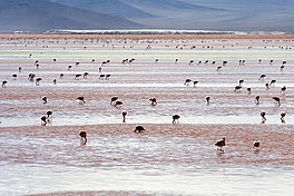
| Laguna Colorada | |
|---|---|
 Andean Flamingos | |
| Location | Potosí, Bolivia |
| Coordinates | 22°11′55″S 67°46′52″W / 22.19861°S 67.78111°W |
| Type | salt lake[1] |
| Primary inflows | Rio Sulor[2] |
| Basin countries | Bolivia |
| Max. length | 10.7 km (6.6 mi) |
| Max. width | 9.6 km (6.0 mi) |
| Surface area | 60 km2 (23 sq mi) |
| Average depth | 0.35 m (1 ft 2 in) |
| Max. depth | 1.5 m (4 ft 11 in) |
| Shore length1 | 35 km (22 mi) |
| Surface elevation | 4,278 m (14,035 ft) |
| Islands | numerous, sometimes huge borax deposit islands[1] |
 | |
| Official name | Los Lípez |
| Designated | 27 June 1990 |
| Reference no. | 489[3] |
| 1 Shore length is not a well-defined measure. | |
Laguna Colorada (Red Lagoon) is a shallow salt lake in the southwest of the altiplano of Bolivia, within Eduardo Avaroa Andean Fauna National Reserve and close to the border with Chile, notable for the reddish color of its waters.
- ^ a b Amusing Planet website, at Laguna Colorada: The Red Lagoon of Bolivia .
- ^ Hurlbert, Stuart H. (6 Dec 2012). Saline Lakes V: Proceedings of the Vth International Symposium on Inland Saline Lakes. Springer Science & Business Media. p. 264. ISBN 9789401120760.
- ^ "Los Lípez". Ramsar Sites Information Service. Retrieved 25 April 2018.

