| Lake Algonquin | |
|---|---|
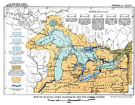
 Map of Glacial Lake Algonquin and its Correlatives (USGS) | |
| Location | North America |
| Group | Great Lakes |
| Coordinates | 47°N 85°W / 47°N 85°W |
| Lake type | former lake |
| Etymology | Algonquin people |
| Primary inflows | Laurentide Glacier |
| Primary outflows | St. Clair River |
| Basin countries | Canada United States |
| First flooded | 11,000 years before present |
| Max. length | 586 mi (943 km) |
| Max. width | 591 mi (951 km) |
| Residence time | 3000 years in existence |
| Surface elevation | 295 ft (90 m) |
| References | United States Geological Survey, George Otis Smith, Director; The Pleistocene of Indiana and Michigan and the History of the Great Lakes; Frank Leverett and Frank B. Taylor; Department of the Interior, Monographs of the United States Geological Survey; Volume LIII; Washington; Government Printing Office; 1915 |
Lake Algonquin was a prehistoric proglacial lake that existed in east-central North America at the time of the last ice age. Parts of the former lake are now Lake Huron, Georgian Bay, Lake Superior, Lake Michigan, Lake Nipigon, and Lake Nipissing.
The lake varied in size, but it was at its biggest during the post-glacial period and gradually shrank to the current Lake Huron and Georgian Bay. About 7,000 years ago, the lake was replaced by Lake Chippewa and Lake Stanley as the glaciers retreated and 3,000 years later by the current Lakes Michigan, Huron, and Superior.
