| Lake Cahuilla | |
|---|---|
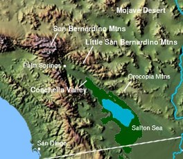
 Region of Lake Cahuilla; the dark green patch is the rough extent of Lake Cahuilla | |
| Location | Baja California, Mexico California, United States |
| Coordinates | 33°18′0.00000″N 115°48′0.00000″W / 33.3000000000°N 115.8000000000°W |
| Type | Prehistoric endorheic lake |
| Part of | Salton Sink |
| Primary inflows | Colorado River San Felipe Creek Whitewater River |
| Primary outflows | Hardy River |
| Max. length | 160 km (99 mi) |
| Max. width | 56 km (35 mi) |
| Surface area | 5,700 km2 (2,200 sq mi) |
| Average depth | 91 m (299 ft) at a surface elevation of 12 meters |
| Surface elevation | 7.6–18.3 m (25–60 ft) |
| Islands | 6 |
Lake Cahuilla (/kəˈwiː.ə/ kə-WEE-ə;[1][2][3] also known as Lake LeConte and Blake Sea) was a prehistoric lake in California and northern Mexico. Located in the Coachella and Imperial valleys, it covered surface areas of 5,700 km2 (2,200 sq mi) to a height of 12 m (39 ft) above sea level during the Holocene. During earlier stages of the Pleistocene, the lake reached even higher elevations, up to 31–52 m (102–171 ft) above sea level. During the Holocene most of the water came from the Colorado River with little contribution from local runoff; in the Pleistocene local runoff was higher and it is possible that Lake Cahuilla was supported solely from local water sources during the Wisconsin glaciation. The lake overflowed close to Cerro Prieto into the Rio Hardy, eventually draining into the Gulf of California.
The lake formed several times during the Holocene, when water from the Colorado River was diverted into the Salton Trough. This tectonic depression forms the northern basin of the Gulf of California, but it was separated from the sea proper by the growth of the Colorado River Delta. Such changes in river courses may have been caused by earthquakes among the numerous faults that cross the region, such as the San Andreas Fault. Conversely, it is possible that the weight of the water itself triggered earthquakes. During its existence, Lake Cahuilla formed strandlines and various beach deposits such as gravel bars and travertine deposits.
The lake existed in several stages over the last 2,000 years, periodically drying and refilling and eventually disappearing sometime after 1580. Between 1905 and 1907, due to an engineering accident, the Salton Sea formed in parts of the lower basin of Lake Cahuilla. Were it not for human intervention, the sea might have grown to the size of prehistoric Lake Cahuilla. Today the former lake bed forms the fertile regions of the Imperial and Coachella Valleys.
The Algodones Dunes were formed from sand deposited by Lake Cahuilla, which was transported by wind toward the area. During its existence, the lake supported a rich biota with fish, bivalves and vegetation on its shorelines. These resources supported human populations on its shores, as evidenced by a number of archeological sites and mythological references to the lake in the traditions of the Cahuilla. The lake may have had profound effects on population genetics and language history of the surrounding regions.
- ^ Cite error: The named reference
Zelasko2021was invoked but never defined (see the help page). - ^ "Cahuilla". Dictionary.com Unabridged (Online). n.d.
- ^ "Cahuilla". The American Heritage Dictionary of the English Language (5th ed.). HarperCollins.

