| Lake Casitas | |
|---|---|
 | |
| Location | Ventura County, California, U.S. |
| Coordinates | 34°23′33″N 119°20′05″W / 34.3924°N 119.3346°W |
| Lake type | Reservoir |
| Primary inflows | Coyote Creek; Santa Ana Creek |
| Primary outflows | Coyote Creek |
| Catchment area | 39 sq mi (100 km2) |
| Basin countries | United States |
| Managing agency | Casitas Municipal Water District |
| Max. length | 3.3 mi (5.3 km) |
| Max. width | 1.9 mi (3 km) |
| Surface area | 1,100 acres (450 ha) |
| Max. depth | 240 feet (73 m)[1] |
| Water volume | 254,000 acre⋅ft (313,000,000 m3) |
| Shore length1 | 32.4 miles (52.1 km)[1] |
| Surface elevation | 338 ft (103 m) |
| Settlements | Oak View, Ojai |
| References | U.S. Geological Survey Geographic Names Information System: Lake Casitas |
| 1 Shore length is not a well-defined measure. | |
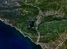
Lake Casitas is a reservoir in Ventura County, California, built by the United States Bureau of Reclamation and completed in 1959.[2] The project provides drinking water and water for irrigation.[3][4] A secondary benefit is flood control. It was the venue for canoeing and rowing at the 1984 Summer Olympics.
Casitas Dam was constructed on Coyote Creek, two miles (3 km) before it joins the Ventura River. Santa Ana Creek and North Fork Coyote Creek also flow into the lake. The system was designed for water from the Ventura River to be diverted into a canal under specific conditions since the impounded watershed is not sufficient to fill the lake.[5] The dam is 279 ft (85 m) creating a lake capacity of 254,000 acre⋅ft (313,000,000 m3).[6] The dam was built as part of the Ventura River Project.
- ^ Carlson, Cheri (April 4, 2016). "Drought uncovers family history buried under Lake Casitas". Ventura County Star. Archived from the original on March 30, 2019. Retrieved April 5, 2016.
- ^ Boyd-Barrett, Claudia (September 8, 2014). "Ventura leans on lake for water for eastern half of city". Ventura County Star.
- ^ Staff (April 17, 2015). "Lake Casitas just 50 percent full". Ventura County Star.
- ^ Carlson, Cheri (March 12, 2019). "Lake Casitas gets OK to divert more water just as it passes the mark to do so". Ventura County Star. Archived from the original on March 29, 2019. Retrieved March 16, 2019.
- ^ Carlson, Cheri (April 18, 2016). "No rain could mean Lake Casitas runs dry in four years". Ventura County Star. Archived from the original on April 20, 2016. Retrieved August 22, 2016.

