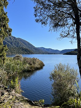
| Lake Ellery | |
|---|---|
 | |
 | |
| Location | Westland District, West Coast region, South Island |
| Coordinates | 44°03′11″S 168°39′22″E / 44.053°S 168.656°E |
| Primary inflows | Silver Stream, Tuesday Brook, Flicker Stream, Ellery Creek, Grebe Creek, Browning Rivulet, Grayling Stream, Rumbling Torrent, and one unnamed stream |
| Primary outflows | Ellery Stream |
| Catchment area | 25 square kilometres (9.7 sq mi) |
| Max. length | 4.6 kilometres (2.9 mi) |
| Max. width | 1.1 kilometres (0.68 mi) |
| Surface area | 380 hectares (940 acres) |
| Max. depth | 90 metres (300 ft) |
| Surface elevation | 12 metres (39 ft) |
Lake Ellery is a glacially-formed lake in South Westland on the West Coast of New Zealand's South Island. It has a steep and entirely forested catchment, with a diverse flora and fauna, and is accessible only by foot or boat. Sediments laid down by its tributaries have preserved a 2,000-year record of ruptures of the nearby Alpine fault.
