| Lake Kununurra | |
|---|---|
 | |
Location in Western Australia | |
| Location | Kununurra, Western Australia |
| Coordinates | 15°48′31.8″S 128°44′22.6″E / 15.808833°S 128.739611°E |
| Type | Freshwater reservoir |
| Primary inflows | Lake Argyle |
| Primary outflows | Ord River |
| Basin countries | Australia |
| Designation | Lakes Argyle and Kununurra Ramsar Site; Ord Irrigation Area Important Bird Area |
| Built | 1959 |
| First flooded | 1963 |
| Max. length | 55 km (34 mi) |
| Max. width | 0.4 km (0.25 mi) |
| Water volume | 90 GL (3.2×10⁹ cu ft) |
| Surface elevation | 40 m (130 ft) |
| Official name | Lakes Argyle and Kununurra |
| Designated | 7 June 1990 |
| Reference no. | 478[1] |
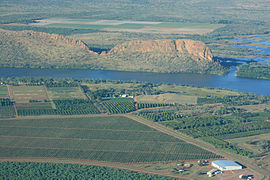
Lake Kununurra is a freshwater man-made reservoir located in the Ord River valley. The lake was formed in 1963 by the construction of the Ord Diversion Dam in Kununurra, northern Western Australia, which was built to supply water to the Ord River Irrigation Area. Prior to the diversion dam construction a natural permanent waterhole (or lake) held back by the Bandicoot Bar was known as "Carlton Reach", which was reputed to be the largest waterhole in the Kimberley.
- ^ "Lakes Argyle and Kununurra". Ramsar Sites Information Service. Retrieved 25 April 2018.
