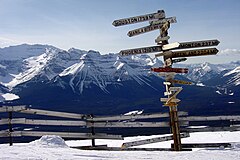
| Lake Louise Ski Resort | |
|---|---|
 Lake Louise in 2004 | |
| Location | Lake Louise, Alberta, |
| Nearest major city | Banff, Alberta Calgary, Alberta |
| Coordinates | 51°26′31″N 116°09′38″W / 51.44194°N 116.16056°W |
| Vertical | 991 m (3,250 ft) |
| Top elevation | 2,637 m (8,650 ft)[1] |
| Base elevation | 1,646 m (5,400 ft) |
| Skiable area | 17 km2 (6.6 sq mi)[2] |
| Trails | 145 [2] |
| Longest run | 8 km (5 mi)[2] |
| Lift system | 8 lifts: - 2 surface lifts - 1 triple - 1 fixed-grip quad - 4 high-speed lifts - 1 six-passenger gondola[1] |
| Lift capacity | more than 14,000 skiers/hr |
| Terrain parks | 4 |
| Snowfall | 454 cm (180 in) per year |
| Website | skilouise.com |
The Lake Louise Ski Resort & Summer Gondola is a ski resort in western Canada, located in Banff National Park near the village of Lake Louise, Alberta. Located 57 km (35 mi) west of Banff, Lake Louise is one of three major[a] ski resorts within Banff National Park.[3]
The resort is situated on the southern slopes of the Slate Range, with most of its skiable terrain on the slopes of Whitehorn Mountain, with additional skiable terrain to the east on the lower western slope of Lipalian Mountain. The overall ski area is between the heights of Mount Richardson, Ptarmigan Peak, Pika Peak and Redoubt Mountain, all around 3,000 m (10,000 ft) above sea level. The base of the slopes is defined by Pipestone River, a tributary of the Bow River, immediately north of the intersections between Highway 1A (Bow Valley Trail), Highway 1 (Trans-Canada Highway), and Highway 93 (Icefields Parkway).
- ^ a b Go Ski. "Lake Louise - Statistics". Archived from the original on 2008-04-21. Retrieved 2008-05-12.
- ^ a b c Lake Louise Mountain Resort. "Mountain Statistics". Retrieved 2008-05-12.
- ^ "Visit Lake Louise | Flights, Holidays & Hotels". British Airways. Retrieved 2018-09-01.
Cite error: There are <ref group=lower-alpha> tags or {{efn}} templates on this page, but the references will not show without a {{reflist|group=lower-alpha}} template or {{notelist}} template (see the help page).

