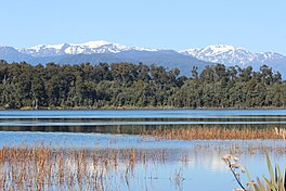
| Lake Mahinapua | |
|---|---|
| Lake Māhinapua, Tāwiri a Te Makō | |
 Lake Mahinapua | |
 | |
| Location | West Coast, South Island, New Zealand |
| Coordinates | 42°48′S 170°55′E / 42.800°S 170.917°E |
| Primary inflows | Frosty Creek, Mirror Creek |
| Primary outflows | Mahināpua Creek |
| Basin countries | New Zealand |
| Max. length | 3 kilometres (1.9 mi) |
| Max. width | 2 kilometres (1.2 mi) |
| Surface area | 3 square kilometres (1.2 sq mi) |
| Surface elevation | 4 metres (13 ft) |
Lake Mahinapua is a shallow lake on the West Coast of New Zealand's South Island. Once a lagoon at the mouth of the Hokitika River, it became a lake when the river shifted its course. Lake Māhinapua was the site of a significant battle between Ngāi Tahu and Ngāti Wairangi Māori, and is regarded by them as a sacred site where swimming and fishing are prohibited. In European times it was part of an inland waterway that carried timber and settlers between Hokitika and Ross until the building of the railway. Today it is protected as a scenic reserve for boating, camping, and hiking.
