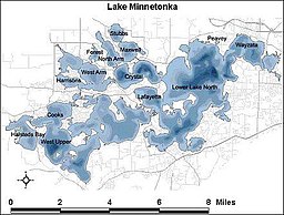
| Lake Minnetonka | |
|---|---|
 | |
 Map | |
| Location | Hennepin and Carver counties, Minnesota, United States |
| Coordinates | 44°56′00″N 93°34′00″W / 44.93333°N 93.56667°W |
| Primary inflows | Six Mile Creek |
| Primary outflows | Minnehaha Creek |
| Basin countries | United States |
| Surface area | 14,528 acres (5,879 hectares) |
| Max. depth | 113 ft (34 m) |
| Shore length1 | 125 mi (200 km) |
| Surface elevation | 929 ft (283 m) |
| Islands | Big Island Crane Island |
| Settlements | Deephaven Excelsior Greenwood Minnetonka Minnetonka Beach Minnetrista Mound Orono Shorewood Spring Park Tonka Bay Victoria Wayzata Woodland |
| 1 Shore length is not a well-defined measure. | |
Lake Minnetonka (Dakota: Mní iá Tháŋka[1]) is a lake located about 16 miles (26 km) west-southwest of Minneapolis, Minnesota. Lake Minnetonka has about 23 named bays and areas.[2] The lake lies within Hennepin and Carver counties and is surrounded by 13 incorporated municipalities. At 14,528 acres (5,879 ha), it is Minnesota's ninth largest lake. It is a popular spot for local boaters, sailors, and fishermen.[3]

- ^ Durand, Paul (1994). Where the waters gather and the rivers meet : (ó-ki-zu wa-kpá) (to meet, to unite) : an atlas of the eastern Sioux. Prior Lake, MN: P.C. Durand. p. 60. ISBN 978-0-9641469-0-7. OCLC 32050105.
- ^ "Water on the Web | Data | West Upper Bay |". www.waterontheweb.org. Retrieved 2021-08-18.
- ^ "Lake Minnetonka Information | Orono, MN". www.ci.orono.mn.us. Retrieved 2022-03-30.

