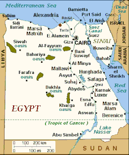
| Lake Nasser | |
|---|---|
 View from Abu Simbel | |
 Map showing the location of the lake | |
| Coordinates | 22°30′N 31°52′E / 22.50°N 31.86°E |
| Lake type | Reservoir |
| Primary inflows | |
| Primary outflows | |
| Basin countries | Egypt, Sudan |
| Max. length | 550 km (340 mi) |
| Max. width | 35 km (22 mi) |
| Surface area | 5,250 km2 (2,030 sq mi) |
| Average depth | 25.2 m (83 ft) |
| Max. depth | 130 m (430 ft) |
| Water volume | 132 km3 (32 cu mi) |
| Shore length1 | 7,844 km (25,735,000 ft) |
| Surface elevation | 183 m (600 ft) |
| 1 Shore length is not a well-defined measure. | |
Lake Nasser (Arabic: بحيرة ناصر Boħeiret Nāṣer, Egyptian Arabic: [boˈħeiɾet ˈnɑːseɾ]) is a vast reservoir in southern Egypt and northern Sudan. It was created by the construction of the Aswan High Dam and is one of the largest man-made lakes in the world.[1] Before its creation, the project faced opposition from Sudan as it would encroach on land in the northern part of the country, where many Nubian people lived who would have to be resettled.[2][3] In the end Sudan's land near the area of Lake Nasser was mostly flooded by the lake.[4] The lake has become an important economic resource in Egypt, improving agriculture and touting robust fishing and tourism industries.
Strictly speaking, "Lake Nasser" refers only to the much larger portion of the lake that is in Egyptian territory (83% of the total), with the Sudanese preferring to call their smaller body of water Lake Nubia (Egyptian Arabic: بحيرة النوبة Boħēret Nubeya, [boˈħeːɾet nʊˈbejjæ]).[5]
- ^ "Aswan High Dam, River Nile, Sudan, Egypt". Water Technology. Retrieved 15 October 2016.
- ^ Scudder, Thayer (2 September 2016). Aswan High Dam Resettlement of Egyptian Nubians. Springer. ISBN 9789811019357. Retrieved 18 November 2016.
- ^ Sofer, Amon (1999). Rivers of Fire: The Conflict Over Water in the Middle East. Rowman & Littlefield. p. 36. ISBN 9780847685110.
- ^ "Governorates of Egypt". Statoids Administrative Divisions of Countries ("Statoids"). Retrieved 16 October 2016.
- ^ Roest, F.C.; Crul, R. C. M. (1995). Current Status of Fisheries and Fish Stocks of the Four Largest African Reservoirs: Kainji, Kariba, Nasser/Nubia and Volta. Food & Agriculture Org. p. 81. ISBN 9789251036839.
