| Lake Nipissing | |
|---|---|
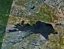
 Satellite view of Lake Nipissing | |
| Location | Ontario |
| Coordinates | 46°16′12″N 079°47′24″W / 46.27000°N 79.79000°W |
| Type | Mesotrophic |
| Etymology | Ojibwe nibiinsing, meaning "at little water" |
| Primary inflows | Sturgeon River, South River, Rivière Veuve |
| Primary outflows | French River |
| Catchment area | 12,300 km2 (4,700 sq mi) |
| Basin countries | Canada |
| Max. length | 65 km (40 mi) |
| Max. width | 25 km (16 mi) |
| Surface area | 873.3 km2 (337.2 sq mi) |
| Average depth | 4.5 m (15 ft) |
| Max. depth | 64 m (210 ft) |
| Water volume | 3.8 km3 (0.91 cu mi) |
| Shore length1 | 795 km (494 mi) (+ 619 km (385 mi) islands) |
| Surface elevation | 196 m (643 ft) |
| Islands | Numerous |
| Settlements | North Bay |
| 1 Shore length is not a well-defined measure. | |

Lake Nipissing (/ˈnɪpəsɪŋ/; French: lac Nipissing, Ojibwe: ᑭᒋᓂᐲᓐᓯᓐᓵᑲᐃᑲᓐ, romanized: Gichi-nibiinsing-zaaga’igan) is a lake in the Canadian province of Ontario. It has a surface area of 873.3 km2 (337.2 sq mi), a mean elevation of 196 m (643 ft) above sea level, and is located between the Ottawa River and Georgian Bay. Lake Nipissing is the third-largest lake entirely in Ontario. It is relatively shallow for a large lake, with an average depth of only 4.5 m (15 ft). The shallowness of the lake makes for many sandbars along the lake's irregular shoreline. The lake reaches a maximum depth of 64 m (210 ft) near the mouth of the French River, off the shore of Blueberry Island. The lake has many islands most of which are protected under the Protection of Significant Wetlands scheme, controlled by the Ministry of Natural Resources and Forestry.
The largest population centre on the lake's shoreline is the city of North Bay. North Bay sits along the lake's northeastern shoreline. Other notable towns include Callander (south of North Bay along Highway 11). The larger towns toward the western end of the lake are Sturgeon Falls, Garden Village, Cache Bay and Lavigne.
