| Lake Rotomahana | |
|---|---|
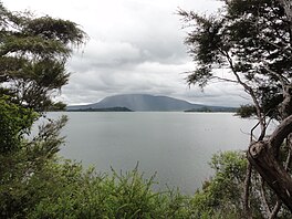
 Lake Rotomahana in 2011 | |
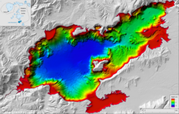
 Bathymetric map of Lake Rotomahana[1] | |
| Location | North Island |
| Group | Rotorua lakes |
| Coordinates | 38°16′S 176°27′E / 38.267°S 176.450°E |
| Lake type | Volcanic crater lake |
| Etymology | From Māori: Hot lake |
| Part of | Ōkataina Caldera |
| Primary inflows | Haumi Stream, Te Kauae Stream, Waimangu Stream, unnamed streams on Mount Tarawera, subsurface |
| Primary outflows | subsurface of at least 1,125 L/s (39.7 cu ft/s).[2] |
| Catchment area | 83.3 km2 (32.2 sq mi)[2]: 56 |
| Basin countries | New Zealand |
| First flooded | 1886 |
| Max. length | 6.2 km (3.9 mi)[3] |
| Max. width | 2.8 km (1.7 mi)[3] |
| Surface area | 8.9 km2 (3.4 sq mi)[2]: 55 |
| Average depth | 51 m (167 ft)[3] |
| Max. depth | 118 m (387 ft),[4]: 41 |
| Surface elevation | 338.7 m (1,111 ft)[2]: 24 |
| Islands | Pātītī Island |
| References | [3] |
Lake Rotomahana is an 890-hectare (2,200-acre)[2]: 55 lake in northern New Zealand, located 20 kilometres to the south-east of Rotorua. It is immediately south-west of the dormant volcano Mount Tarawera, and its geography was substantially altered by a major 1886 eruption of Mount Tarawera. Along with the mountain, it lies within the Ōkataina Caldera. It is the most recently formed larger natural lake in New Zealand, and the deepest in the Rotorua district.
- ^ de Ronde, Cornel E. J.; Caratori Tontini, Fabio; Walker, S. L.; Black, Jenny (2020). "Bathymetric map of Lake Rotomahana". GNS Science Rotorua Lakes Map Series. doi:10.21420/E4FK-8P15. Retrieved 31 August 2023.
- ^ a b c d e Cite error: The named reference
White2016was invoked but never defined (see the help page). - ^ a b c d Lowe, D.J.; Green, J.D. (1987). Viner, A.B. (ed.). Inland waters of New Zealand. Wellington: DSIR Science Information Publishing Centre. pp. 471–474. ISBN 978-0-477-06799-7.
- ^ Cite error: The named reference
Ronde2018was invoked but never defined (see the help page).
