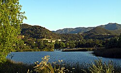
Lake Sherwood, California | |
|---|---|
 Lake Sherwood and the Santa Monica Mountains | |
 Location of Lake Sherwood in Ventura County, California. | |
| Coordinates: 34°07′34″N 118°53′17″W / 34.12611°N 118.88806°W | |
| Country | United States |
| State | California |
| County | Ventura |
| Area | |
| • Total | 3.323 sq mi (8.607 km2) |
| • Land | 3.135 sq mi (8.121 km2) |
| • Water | 0.188 sq mi (0.486 km2) 5.65% |
| Elevation | 1,194 ft (364 m) |
| Population | |
| • Total | 1,759 |
| • Density | 530/sq mi (200/km2) |
| Time zone | UTC-8 (Pacific (PST)) |
| • Summer (DST) | UTC-7 (PDT) |
| ZIP codes | 91361 |
| Area code | 805 |
| FIPS code | 06-39735 |
| GNIS feature ID | 2585428 |
| U.S. Geological Survey Geographic Names Information System: Lake Sherwood, California | |
Lake Sherwood is an unincorporated community in the Santa Monica Mountains, in Ventura County, California overlooking Lake Sherwood reservoir. It is a body contact lake (swimming, fishing, standup paddleboarding (SUP), and boating are allowed), located south of the Conejo Valley and city of Thousand Oaks, and west of Westlake Village. The lake is naturally fed by thousand of acres of open-space, watershed mountains and natural springs.
While homes have been around the lake since the reservoir was created by the construction of Sherwood Dam in 1901, the community expanded with the development of the Sherwood Country Club golf course surrounded by luxury homes.
The ZIP Code is 91361, and the community is inside area code 805. The population was 1,759 at the 2020 census. For statistical purposes, the United States Census Bureau has defined Lake Sherwood as a census-designated place (CDP).[2] The census definition of the area may not precisely correspond to local understanding of the area with the same name.
- ^ U.S. Census Archived 2012-07-02 at the Wayback Machine
- ^ a b U.S. Geological Survey Geographic Names Information System: Lake Sherwood, California
- ^ "Census Data: Lake Sherwood (cdp)". United States Census Bureau. Retrieved July 14, 2021.

