| Lake St. Clair | |
|---|---|
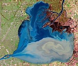
 false-color imagery from Sentinel-2, showing Lake St. Clair in April 2023 | |
| Location | (Great Lakes) |
| Coordinates | 42°28′N 82°40′W / 42.467°N 82.667°W |
| Type | Freshwater lake |
| Primary inflows | St. Clair River, Thames River, Sydenham River, Clinton River, Pine River |
| Primary outflows | Detroit River |
| Basin countries | Canada, United States |
| Max. length | 26 mi (42 km)[1] |
| Max. width | 24 mi (39 km)[1] |
| Surface area | 430 sq mi (1,114 km2)[1][2] |
| Average depth | 11 ft (3.4 m)[1] |
| Max. depth | 27 ft (8.2 m) |
| Water volume | 0.82 cu mi (3.4 km3)[1] |
| Residence time | 7 days |
| Shore length1 | 130 mi (210 km) plus 127 mi (204 km) for islands[3] |
| Surface elevation | 574 ft (175 m) |
| Islands | Gull Island, Harsens Island, Strawberry Island Fantasy Island and Peche Island |
| Settlements | Detroit |
| 1 Shore length is not a well-defined measure. | |
Lake St. Clair (French: Lac Sainte-Claire) is a freshwater lake that lies between the Canadian province of Ontario and the U.S. state of Michigan. It was named in 1679 by French Catholic explorers after Saint Clare of Assisi, on whose feast day they first saw the lake.
It is part of the Great Lakes system (although not considered one of the five Great Lakes), and along with the St. Clair River and Detroit River, Lake St. Clair connects Lake Huron (to the north) with Lake Erie (to the south). It has a total surface area of about 430 square miles (1,100 km2) and an average depth of just 11 feet (3.4 m); to ensure an uninterrupted waterway, government agencies in both countries have maintained a 30-foot-deep (9.1 m) shipping channel through the shallow lake for more than a century.
- ^ a b c d e Cite error: The named reference
LakeStClairwas invoked but never defined (see the help page). - ^ Cite error: The named reference
U.S.Armywas invoked but never defined (see the help page). - ^ "Shorelines of the Great Lakes". Michigan Department of Environmental Quality. Archived from the original on April 5, 2015.
