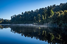
| Lake Wahapo | |
|---|---|
| Wahapako (Māori) | |
 Lake Wahapo | |
 | |
| Location | Whataroa, Westland District, South Island |
| Coordinates | 43°14′56″S 170°15′58″E / 43.249°S 170.266°E |
| Primary inflows | Waitangitāhuna River |
| Primary outflows | Ōkārito River |
| Catchment area | 90 km2 (35 sq mi)[1] |
| Basin countries | New Zealand |
| Max. length | 2.6 km (1.6 mi) |
| Max. width | 1.2 km (0.75 mi) |
| Surface area | 2.3 km2 (0.89 sq mi) |
| Shore length1 | 6.8 km (4.2 mi) |
| Surface elevation | 48 m (157 ft) |
| 1 Shore length is not a well-defined measure. | |
Lake Wahapo (Māori: Wahapako) is a small glacial lake in South Westland, New Zealand, within the Westland Tai Poutini National Park and near the township of Whataroa. It was a traditional mahinga kai (food-gathering place) for local Māori. State Highway 6 skirts the lake's southern shore. The lake discharges to the Ōkārito River via a small hydroelectric power station commissioned in 1960. The ecology of the lake has altered considerably since 1967, when the Waitangitāhuna River changed course to flow into the lake.
