Lakeside, Ohio | |
|---|---|
 Lakeside's shoreline | |
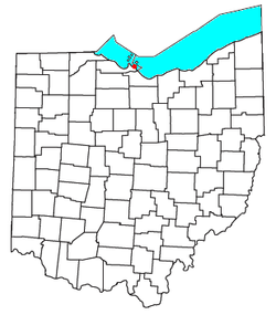
 Location of Lakeside, Ohio | |
| Coordinates: 41°32′30″N 82°45′07″W / 41.54167°N 82.75194°W | |
| Country | United States |
| State | Ohio |
| County | Ottawa |
| Township | Danbury |
| Area | |
| • Total | 0.69 sq mi (1.78 km2) |
| • Land | 0.69 sq mi (1.78 km2) |
| • Water | 0.00 sq mi (0.00 km2) |
| Elevation | 607 ft (185 m) |
| Population (2020) | |
| • Total | 668 |
| • Density | 970.93/sq mi (374.83/km2) |
| Time zone | UTC-5 (Eastern (EST)) |
| • Summer (DST) | UTC-4 (EDT) |
| ZIP codes | 43440 |
| FIPS code | 39-41552 |
| GNIS feature ID | 2628923[2] |
| Website | www |
Lakeside is a private community and census-designated place in Danbury Township, Ottawa County, Ohio, United States, on the shores of Lake Erie.[2] It was formed in 1873 by members of the Methodist Church and remains a church-affiliated vacation resort and United Methodist Annual Conference site. It is one of only a few continuously operating Independent Chautauquas that persist in the 21st century. Located just west of the village of Marblehead, the community is approximately one square mile in size. The entire community is listed on the National Register of Historic Places as the Lakeside Historic District.
As an unincorporated community, Lakeside is governed by the Lakeside Association, a company whose CEO is the de facto leader of the community. Its current CEO is Charles Allen.[3]
| Census | Pop. | Note | %± |
|---|---|---|---|
| 2020 | 668 | — | |
| U.S. Decennial Census[4] | |||
- ^ "ArcGIS REST Services Directory". United States Census Bureau. Retrieved September 20, 2022.
- ^ a b c U.S. Geological Survey Geographic Names Information System: Lakeside, Ohio
- ^ "Directory & Contact".
- ^ "Census of Population and Housing". Census.gov. Retrieved June 4, 2016.
