| Lal Bahadur Shastri Marg | |
|---|---|
Lal Bahadur Shastri Marg marked in Red on Mumbai area map | |
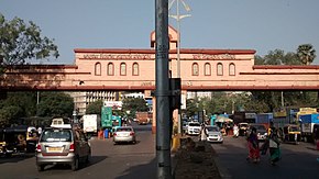
 Entrance to Thane along LBS Marg | |
| Route information | |
| Maintained by Brihanmumbai Municipal Corporation, Thane Municipal Corporation | |
| Length | 21 km (13 mi) |
| Major junctions | |
| North end | Thane |
| Marathon Chowk (Teen Haath Naka) in Thane, JVLR in Gandhi Nagar, Vikhroli Andheri-Ghatkopar Link Road in Ghatkopar SCLR in Kurla BKC Road in Kurla | |
| South end | Sion, Mumbai |
| Location | |
| Country | India |
| States | Maharashtra |
| Districts | Thane, Mumbai Suburban, Mumbai City |
| Major cities | Thane, Mumbai |
| Highway system | |
Lal Bahadur Shastri Marg, commonly known by its abbreviation LBS Marg,[1] is a 21 km long, major arterial road connecting the neighbouring city of Thane with Sion in Mumbai.[2] It passes through heavily populated areas of the Eastern Suburbs in Mumbai and is heavily congested. Approximately, 3 lakh vehicles use this road daily.[3] The road is named after Lal Bahadur Shastri, the second Prime Minister of India.
- ^ Pandurang Mhaske (29 November 2011). "BMC to buy its way into LBS road-widening". Dnaindia.com. Retrieved 18 July 2013.
- ^ "6 months on, Mumbai's LBS Rd stretch remains dug up". Dnaindia.com. 9 November 2012. Retrieved 3 May 2013.
- ^ Cite error: The named reference
MumbaiMirror1was invoked but never defined (see the help page).
