Lampeter Velfrey
| |
|---|---|
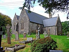
 Parish Church of St Peter | |
Location within Pembrokeshire | |
| Population | 1,205 (in 2011) |
| OS grid reference | SN 1560 1442 |
| • Cardiff | 68.0 mi (109.4 km) |
| • London | 196.0 mi (315.4 km) |
| Community |
|
| Principal area | |
| Country | Wales |
| Sovereign state | United Kingdom |
| Post town | WHITLAND |
| Postcode district | SA34 |
| Post town | NARBERTH |
| Postcode district | SA67 |
| Dialling code | 01834 |
| Police | Dyfed-Powys |
| Fire | Mid and West Wales |
| Ambulance | Welsh |
| UK Parliament | |
| Senedd Cymru – Welsh Parliament | |
Lampeter Velfrey (Welsh: Llanbedr Felfre) is a community and parish[1] in the county of Pembrokeshire, Wales, which lies 68.0 miles (109.4 km) from Cardiff and 196.0 miles (315.4 km) from London.[2][3] In 2011 the population of the parish was 1,205, with 20.2 per cent of them able to speak Welsh.[4] Besides Lampeter Velfrey village, other settlements in the community include Princes Gate, Ludchurch, Llan-mill, Melinau and Tavernspite.
The old Medieval spelling was "Velfre"[5]
- ^ "GENUKI: Lampeter Velfrey pre-1850 parish map 122". Retrieved 24 September 2018.
- ^ Felfre Bangor University Placenames Unit (Canolfan Bedwyr); Archived 12 May 2014 at the Wayback Machine accessed 9 May 2014
- ^ Google Maps (Map).
- ^ "Custom report - Nomis - Official Labour Market Statistics".
- ^ Google Books website; An Inventory of the Ancient Monuments of Wales; accessed 9 May 2014
