Lancaster County | |
|---|---|
 Central Lancaster, the county seat, with the county courthouse visible | |
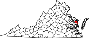
 Location within the U.S. state of Virginia | |
 Virginia's location within the U.S. | |
| Coordinates: 37°43′N 76°25′W / 37.71°N 76.41°W | |
| Country | |
| State | |
| Founded | 1651 |
| Seat | Lancaster |
| Largest town | Kilmarnock |
| Area | |
| • Total | 231 sq mi (600 km2) |
| • Land | 133 sq mi (340 km2) |
| • Water | 98 sq mi (250 km2) 42.4% |
| Population (2020) | |
| • Total | 10,919 |
| • Density | 47/sq mi (18/km2) |
| Time zone | UTC−5 (Eastern) |
| • Summer (DST) | UTC−4 (EDT) |
| Congressional district | 1st |
| Website | www |
Lancaster County is a county located on the Northern Neck in the Commonwealth of Virginia. As of the 2020 census, the population sits at 10,919.[1] Its county seat is Lancaster.[2]
Located on the Northern Neck near the mouth of the Rappahannock River, Lancaster County is part of the Northern Neck George Washington Birthplace wine-growing region recognized by the United States as an American Viticultural Area.[citation needed] Lancaster County is the most densely populated county in the Northern Neck.[citation needed] The largest town in Lancaster County is Kilmarnock, Virginia. The county's area code is 804.
- ^ "Lancaster County, Virginia". United States Census Bureau. Retrieved January 30, 2022.
- ^ "Find a County". National Association of Counties. Retrieved June 7, 2011.