Landskrona | |
|---|---|
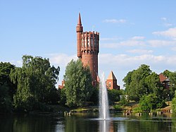
 The old water tower viewed across St. Olof's lake | |
| Coordinates: 55°52′14″N 12°49′52″E / 55.87056°N 12.83111°E | |
| Country | Sweden |
| Province | Scania |
| County | Scania County |
| Municipality | Landskrona Municipality |
| Charter | 15th century |
| Area | |
| • Total | 12.95 km2 (5.00 sq mi) |
| Population (31 December 2020) | |
| • Total | 33,372 |
| • Density | 2,572/km2 (6,660/sq mi) |
| Time zone | UTC+1 (CET) |
| • Summer (DST) | UTC+2 (CEST) |
Landskrona is a town in Scania, Sweden. Located on the shores of the Öresund, it occupies a natural port, which has lent the town at first military and subsequent commercial significance. Ferries operate from Landskrona to the island of Ven, and for many years there was also a connection to Copenhagen. Landskrona is part of the Øresund region.
It is the seat of Landskrona Municipality. Landskrona is also the name of a district in Landskrona Municipality which is slightly smaller than the urban area.
- ^ "Statistiska tätorter 2018; befolkning, landareal, befolkningstäthet". scb.se (in Swedish). SCB. Retrieved 4 July 2020.


