Langley, Virginia | |
|---|---|
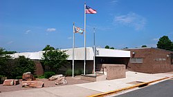
 Langley High School | |
| Coordinates: 38°56′47″N 77°9′32″W / 38.94639°N 77.15889°W | |
| Country | United States |
| State | Virginia |
| County | Fairfax |
| Area | |
| • Total | 2.2 sq mi (5.7 km2) |
| Population (2022) | |
| • Total | 1,930 |
| • Density | 880/sq mi (340/km2) |
| Time zone | UTC−5 (Eastern (EST)) |
| • Summer (DST) | UTC−4 (EDT) |
| ZIP Codes | 22101–22102 |
| GNIS feature ID | 1495816[1] |
This article includes a list of references, related reading, or external links, but its sources remain unclear because it lacks inline citations. (June 2024) |
Langley is an unincorporated community in the census-designated place of McLean in Fairfax County, Virginia, United States. The name "Langley" often occurs as a metonym for the Central Intelligence Agency (CIA), whose headquarters, the George Bush Center for Intelligence, is in Langley.
The land which makes up Langley today once belonged to Thomas Lee, former Crown Governor of the Colony of Virginia from 1749 to 1750. Lee's land was named Langley in honor of Langley Hall, which formed part of the Lee home estate in Shropshire, England.[2] In 1839 Benjamin Mackall purchased 700 acres (283 ha) of land from the Lee family,[3] while keeping the name.[citation needed]
The community was essentially absorbed into McLean many years ago,[when?] although there is still a Langley High School.[4] In addition to its roles as a bedroom community for Washington, D.C., and as home to the CIA's headquarters, the area is the site of the Federal Highway Administration's Turner-Fairbank Highway Research Center and formerly the Claude Moore Colonial Farm of the National Park Service, now permanently closed.
- ^ U.S. Geological Survey Geographic Names Information System: Langley, Virginia
- ^ The CIA Campus: The Story of Original Headquarters Building
- ^ Compare:Kessler, Ronald (January 10, 2012) [1992]. Inside the CIA. New York: Simon and Schuster. p. 347. ISBN 9781439140772. Retrieved June 4, 2023.
[...] Benjamin Mackall, who acquired the Langley estate from the Lee family in 1836.
- ^ "Langley HS Map" (PDF). Fairfax County Public Schools. 2008. Archived from the original (PDF) on December 24, 2012. Retrieved October 6, 2008.


